Under this sub-research focus area, research projects focus on enhancing flood risk management, climate resilience, and environmental sustainability, particularly in vulnerable urban coastal regions. From nature-based flood mitigation in Puerto Rico, integrating social vulnerability and environmental factors, to AI-driven flood forecasting for urban areas like Mumbai and New York City, these studies employ cutting-edge technology to predict and manage flood events. Projects also explore high-resolution inland flooding risk mapping in Puerto Rico and the U.S. Virgin Islands, the development of flash flood alert systems in New York City, and the use of remote sensing to assess flood risks and water quality in urbanized coastal regions like Long Island. These initiatives contribute to sustainable development by enhancing disaster resilience, improving resource management, and mitigating the socio-economic and environmental impacts of flooding, directly supporting global efforts for climate action, disaster risk reduction, and resilient urban infrastructure.
The Following Research Projects are in progress.
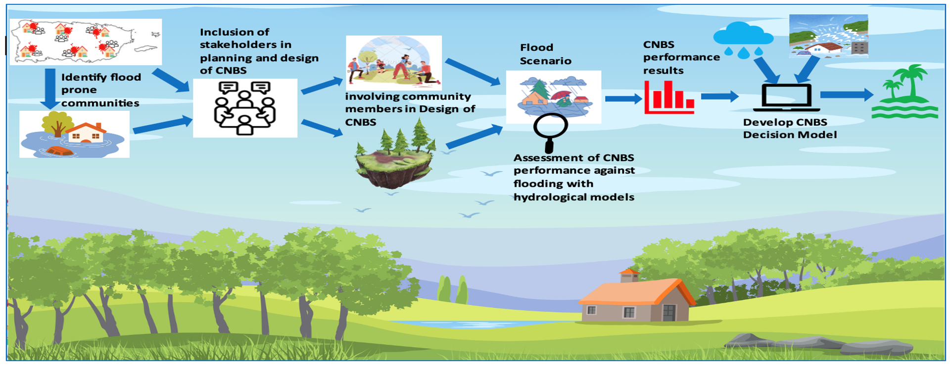
A Community-Driven Decision Support Framework for Nature-Based Flood Mitigation in Puerto Rico: Integrating Social Vulnerability and Environmental Indices
Eromosele Emmanuel Osuide, Doctoral Candidate
This research focuses on evaluating the effectiveness of nature-based solutions (NBS) for climate change adaptation and flood mitigation in Puerto Rico, with special attention to the disproportionate impact of flooding on various demographics. Emphasizing the most vulnerable regions and critical infrastructure, the study integrates community-driven approaches in designing and adapting NBS to address local needs. A key aspect of the research is the development of a collaborative framework that actively involves stakeholders and communities in decision-making, ensuring that the solutions are tailored to their specific demands. An interactive decision support model will be created to recommend optimal NBS for mitigating flood scenarios, including extreme rainfall events. This project is crucial for enhancing resilience in flood-prone areas, promoting sustainable development, and ensuring equitable climate adaptation strategies. It aligns with global sustainability efforts by fostering community participation, reducing vulnerabilities, and improving disaster preparedness in the face of climate change.
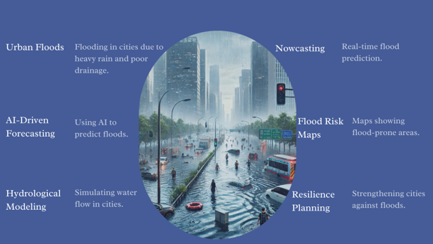
AI-Driven Forecasting and Modelling of Urban Floods: A Case Study of Mumbai, India
Ali Haider, Doctoral Candidate
Urban flooding poses a significant challenge in rapidly expanding metropolitan regions, with devastating socio-economic and infrastructural consequences. My research focuses on developing an AI-based approach for simulating and forecasting urban flood scenarios, specifically targeting Mumbai. By integrating machine learning models with hydrometeorological, remote sensing, and topographical data, this study aims to enhance real-time flood prediction and risk assessment.
A key aspect of this research involves analyzing historical flood events, rainfall patterns, land use changes, and terrain characteristics to improve model accuracy. The findings not only contribute to urban flood management strategies in Mumbai but also offer insights applicable to other densely populated coastal cities, such as New York City. By leveraging AI-driven techniques, this work aspires to aid policymakers and urban planners in mitigating flood risks and improving climate resilience in vulnerable urban environments.
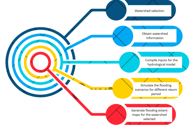
Inland Flooding in Puerto Rico and U.S Virgin Islands
Ana Maria Mejia Manrique, Doctoral Candidate
This research aims to develop high-resolution inland flooding risk maps for Puerto Rico and the U.S. Virgin Islands, incorporating updated Depth-Duration-Frequency (DDF) curves to refine design rainfall estimates essential for hydrological modeling. By integrating environmental factors such as soil properties, land use, and topography, the study enhances flood risk assessment, providing a more accurate understanding of flood vulnerabilities. The final product will offer comprehensive flood maps that identify at-risk areas and support the development of effective mitigation strategies. This work is highly relevant to the UN Sustainable Development Goals, particularly those focused on climate resilience, sustainable cities, and disaster risk reduction. By improving flood risk assessments and promoting informed decision-making, the research contributes to reducing the impacts of extreme weather events, protecting vulnerable communities, and supporting long-term sustainable development in the region. It aims to foster better preparedness and adaptive strategies in the face of climate change.
Flood Events Warning System in NYC
Shima Kamali, Doctoral Candidate
This research focuses on developing an AI-driven flash flood alert system for New York City, aiming to quickly detect and notify residents of impending flash floods. By utilizing machine learning models, the system can accurately predict real-time flood depth, enhancing the ability to respond to flood events in a timely manner. The system is designed to improve urban risk management and disaster preparedness, offering a scalable solution that can be applied to other flood-prone metropolitan areas. This project is directly relevant to the UN’s Sustainable Development Goals, as it supports building resilient cities and communities, enhancing climate action efforts, and improving disaster risk management. By leveraging advanced technologies for early warning systems, it aims to minimize the socio-economic and environmental impacts of floods, contributing to the overall goal of reducing vulnerabilities in urban areas and fostering long-term sustainability in the face of climate change.
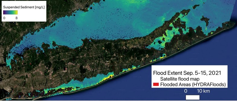
Remote Sensing of Flood Risk and Water Quality in a Vulnerable Urban Coastal System
Britnay Beaudry, Doctoral Candidate
This project aims to link remote sensing of flood risk and extreme inundation events in heavily urbanized coasts to remote sensing of key coastal hazards that severely impact ecosystem health, human health, and quality of life. Among the main objectives of this work are to analyze change in land use/cover over the Long Island subregion to better distinguish the change in impervious surfaces as it relates to flood risk; apply, for the first time, the HYDRAFloods tool to monitor flood extent in the heavily urbanized NYC-Long Island Sound region by incorporating in‐situ tide gauge measurements; and link extreme flood events to changes in coastal water quality using medium and high resolution sensors. Data from this project will help the scientific community and the Long Island community further understand the environmental factors affecting flooding in this area, its impact on key ecosystem processes and water resources, and can assist managing authorities to improve management of coastal hazards.